|

HISTORY
Ph.D. in Assyriology and Northwest Semitic Epigraphy, the
University of Tübingen, 1984
Professor, Department of History and Archaeology, AUB, since
October 2001
Chair, Department of History and Archaeology, AUB, from 2010
to 2013
Chair, Department of History and Archaeology, AUB, from
October 2001 to October 2004
Associate Dean, Faculty of Arts and Sciences, AUB, from
October 1, 2004 to September 30, 2009
Joined the Department of History and Archaeology in 1985.
Co-director of the Beirut Excavations: Site BEY 020 between
1994 and 1997
Co-director of the Tell el-Burak and Tell Fadous-Kfarabida
Archaeological Projects since 2001 and 2004 respectively.
---------------------------------------------------------------------------------------------
This chapter presents a survey of the history of the Aramaeans
of Syria from their origin and state formation untill the end of
their existence as independent polities; it takes into account
the latest written and archaeological evidence. Emphasis will be
laid on the formative period of Aramaean history, the
understandind of which has drastically changed in the recent
discoveries.
1.
GEOGRAPHICAL AND CHRONOLOGICAL SCOPE
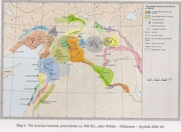
The geographical scope of this coincides roughly with the bordes
of the modern state of the Syrian Arab Republic, infringing in
the north on the Amuq Valley and the slopes of the Amanus
Mountains, which are situated in Modern Turkey. It is within
this geographical space that we can trace the origin and
development of the Aramaean states of ancient Syria.
[1]
Chronologically, this chapter deals with the Iron Age I
and the larger part of the Iron Age II (ca. 1200-622 B.C.), a
period that witnessed the rise and decline of the Aramaean
polities. After this period, and in spite of the fact that
Aramaean culture continued to thrive, these polities ceased to
exist. Their political history thus starts after the collapse of
the Late Bronze Age city-states and ends with the Assyrian
conquest of Syria and their incorporation into the territory and
administrative system of the imperial Assyrian state.
It is important to stress in this context the fact that Syria
toward the end of the Late Bronze Age had a geopolitical
landscape that was totally different from the one provided by
the Neo-Assyrian annals, the Iron Age Hittite-Luwian, and the
Aramaic royal inscriptions. [2]
All the kingdoms that
1.
Cf the map in the frontispiece.
2.
For the Late Bronze Age kingdoms of Syria, see Klengel 1992.
existed in the 2nd millennium B.C. disappeared and were replaced
by new polities, some ruled by Luwian-speaking dynasts and some
ruled by Semitic-speaking Aramaean rulers. It is the history of
the latter kingdoms that is the focus of this chapter.
However, the history of the Aramaeans of ancient Syria is
closely connected with that of the Neo-Hittite or Luwian states.
The latte rare “rump” states that were created from and on the
ruins of the Late Bronze Age Hittite Empire.
[3] Newly discovered Luwian
inscriptions [4] have led to the
conclusion that the vacuum created by the collapse of the
Hittite Empire around 1200 B.C. was filled immediately—but only
partly –by surviving polities whose rulers were of Hittite royal
descent. Not only did these local dynasties continue to rule but
they expanded their territories at the expense of the former
Late Bronze age Syrian kingdoms.
New epigraphic material reveals that next to the kingdom of
Carchemish, which had survived the collapse of the Hittite
Empire [5], another state called
Walastin or Palistin was immediately formed and claimed dominion
over a large part of central and western Syria during the early
Iron Age, in the years immediately following its collaps.[6]This
new kingdom, which was ruled by a local dynasty of Hittite
descent, was founded on the ruins of the former kimgdom of
Mukish in the Amuq plain, with Tell Tayinat as its capital.
This is suggested by the inscriptions of its rulers, Taitas,
which were found in Aleppo and Hamath.
[7] This epigraphic evidence raises the possibility that
local dynasty (next to that of Carhemish and Malatya) survived
the Hittite Empire’s collapse [8]
and continued to rule in the tradition of the former Hittite
state over a territory stretching from the Amuq plain to the
Orontes Valley, including Aleppo and Hamath. These Neo-Hittite
or Luwian states were the direct neighbors of Aramaic-speaking
communities and included probably among their population large
groups of the latter. So both the territory and the history of
Aramaeans and Luwians are imbricated and often difficult to
disentangle for lavk of sufficient documentation. This is mainly
true for the period of formation of the Aramaean states durind
which the political landscape of Syria appears to be
3.
Harrison 2009b; 187.
4.
Hawkins 2009
5.
Hawkins 1988; see also Klengel 1992; 183f
6.
Harrison2009a; fig. 1
7.
Hawkins 2011
8.
Harrison 2009a: 174
”fragmented ”, or ”balkanized”[9].
As a result, any history of the Aramaeans of ancient
Syria
will have to take into account this close interconnection.
2.
THE SOURCES FOR A HISTORY OF THE ARAMAEANS OF ANCIENT SYRIA
2.1 The Written Record
The first problem that the historian of the Aramaeans of ancient
Syria faces is the scarcity are the annals of the Middle-and
Neo-Assyrian kings,[10] the
Luwian[11] royal inscriptions,
and the inscriptions left by the Aramaeans themselves.[12]
The biblical account (mainly 1 Kgs 11: 23-25;
15:18;20:1-34; 22: 1-4; 2 Kgs 6:8-33; 7:1-8; 7-15;12:18-19;
13:3-7, 24-25;15: 37; 16:5-9), which often deals with e tens
relations between the Israelite and Aramaean kingdoms has be
used with great caution. It is mainly relevent for the hisory of
the Aramaean kingdom of Aram-Damascus.[13]
2.2 The Archaeological Record
In the absence of a comprehensive corpus of written sources
covering the entire period of Aramaean history, one has to tur
nto the archaeological record to try and fill in the gaps left
by the texts. This task is not easy for here, too, one is faced
with the problematic and lacunal nature of the evidence. Until
the end of 20th century, little was known about the Iron Age I,
which is the period that saw the formation of the Aramaean
states. Little was also known about the layout and organization
of the Aramaean cities and territories in the Iron Age II
because of the very limited number of excavated sites with
substantial Iron Age remains. Apart from the evidence from early
20th-century exacavations (Tell Halaf,
[14]
9.
Harrison 2009b: 187.
10.
Grayson 1991; id. 1996; Tadmor 1994; Leichty 2011.
11.
Hawkins 2000.
12.
KAI 201-227; Abou Assaf – Bordreuil – Millard 1982; Biran –
Naveh 1993; iid; 1995; Schwiderski (ed.) 2004, Pardee 2009
a; id. 2009b.
13.
Kraeling 1918; Unger 1957; Pitard 1987; Reinhold 1989;
Axskjöld 1998; HafÞ`orsson 2006.
14.
Von Oppenheim 1931; id. 1943; id.1950; id. 1955; id. 1962.
Tell Fekheriye,[15] Zincirli,[16]
Tell Tayinat, [17] and
Hamath),[18] no published
information was avaible. In spite o fits importance the evidence
from the above-mentioned sites gave only a truncated view of the
Aramaean settlement. It first focused exclusively on large urban
sites and within these settlements on the upper cities and their
Iron Age II monumental architeculture. It entirely neglected the
lower cities where the domestic and industrial quarters were
located as well asthe small rural settlements.
With few exceptions, little attention was also given in these
eccavations to statigraphy and to the establishment of reliable
pottery sequences.[19] This
failure has led to a major difficulty in interpreting the
results of surveys that covered large areas of the Syrian
territory in the 2nd half of the 20th century. Little can be
gathered about the Iron Age occupation from most of them because
scholars were unable to identify and to determine clearly the
nature and date of the Iron Age pottery. So in spite of the
large number of surveys only the results of most recent ones,
such as those at Tell Tayinat[20]
and the Euphrates,[21] revealed
substantial information about the settlement pattern and
distribution during the Iron Age. Real progress has nevertheless
been made in the last two decades regarding the Iron Age
archaeology of Syria. Next to surveys, new excavations such as
those of Tell Afis[22] and Tell
Qarqur[23] have yielded refined
pottery sequences ranging from the Iron Age I until the end of
Iron Age II, allowing a better understanding of the
characterstics of the Early Syrian Iron Age. This new evidence
has changed our understandind of the situation that prevailed in
the period immediately following the collapse and shed new light
on the origin and formation of the Iron Age polities of ancient
Syria.
In addition to these new excavations, work recently
resumed on serveral major sites that had been excavated at the
beginning of the 20th century yielding extremely important new
archaeological and epigraphic evidence, allowed for new insights
into the history of some Aramaean kingdoms.
15.
McEwan et al. 1858.
16.
Von Luschan 1893; id. 1898; id. 1902; id. 1911; id. 1943.
17.
Haines 1971.
18.
Fugmann 1958 and Riis 1948.
19.
Jamieson 2000: 261-263 and n. 7.
20.
Harrison 2009a.
21.
Wilkinson 1995.
22.
Mazzoni 1995; ead. 2000a; ead. 2000b; ead. 2000c; ead
Cecchini – Mazzoni (eds.) 1998; Venturi 1998; id. 2000.
23.
Dornemann 2002 and id. 2003.
These sites are Tell Fekheriye[24]
and Tell Halaf[25] on the Khabur,
Tell Ahmar[26] on the Euphrates,
Zincirli[27] on the eastern
slopes of the Amanus Mountains, Tell Tayinat[28]
in the plain of Antioch, and Aleppo[29]
in central-northern Syria.
2.3 Origin of Name ’’Aramaean’’
Before dealing with the history of the Aramaean of ancient Syria
it is important to define the origin of the appellation ”Aramaeans.”
This designation dervies from the geographical name Aram, which
appears for the first time in connection with groups called
ahlamu[30]
in the Middle–Assyrian texts of Tiglath-Pileser I
(III4-1076 B.C.) and Assur-bel-kala (1073-1056 B.C.).[31]
The inscriptions of these 11th-century B.C. kings mention
ahlamu of the land Aram or ahlamu-Aramaeans,[32]
the land Aram indicating the area between Khabur and
Euphrates [33] as well as the
west bank of the Euphrates, [34]
since these ahlamu-Aramaeans moved freely as far as Jabar
Bishri, Palmyra, and
Mount Lebanon.
[35] It is interesting to note in
this context that later Aramaean dynasts never refer to
themselves as Aramaeans or their country as Aram, with the
exception of the king of Aram-Damascus since his kingdom was
also called Aram. In the 8th century B.C. aramaic inscriptions
of Sefire (KAI 222-224) expressions ”All Aram” and ”Upper and
Lower Aram” were variously interpreted
[36] but it can be safely argued that ”All Aram” refers
to a geographical area [37] that
included the territorieso f the Aramaean and non-Aramaean
kingdoms united in the coalition against Mati’el of Aprad, and
that roughly covers
24.
Bonatz – Bartl – Gilibert – Jauss 2008: 89-135.
25.
Cholidis – Martin 2002; iid (eds.) 2010; iid. (eds.) 2011;
Baghdo – Martin – Novak – Orthmann (eds.) 2009; iid. (eds.)
2012; Novak 2010.
26.
Bunnens 1995a and Roobaert – Bunnens 1999: 167-172.
27.
Schloen – Fink 2009a; iid. 2009b; iid. 2009c.
28.
Harrison 2009a and id. 2009b.
29.
Kohlmeyer 2000; id. 2009, id. 2012 ; Gonnella – Khayata –
Kohlmeyer 2005.
30.
Postgate 1981: 48-50 and Lipinski 2000a: 37f.
31.
Nashef 1982: 34f. For earlier occurences of the term Aram,
see Reinhold 1989: 23-38 and, more recently Lipinski 2000a:
26-40.
32.
Nashef 1982.: 35.
33.
Ibid.
34.
For the later use and meaning of the term Aram, see the
review in Sader 2010: 276f.
35.
Grayson 1991:23, 37f.
36.
Sader 1987: 279-281.
37.
Puitard 1987:178-179; Fitzmeyer [2] 1995: 65-68; Grosby
1995; Sader 2000: 70; Kahn 2007.
the boundaries of modern Syria, while ”Upper and Lower Aram” may
refer to North and South Syria, respectively.[38]
So Aram is a geographical term that refers at times to
part and at others to all of the Syrian territory in the Iron
Age, hence the appellation ”Aramaean” given to the
1st-millennium B.C. inhabitants of Syria.
3. The ARAMAEANS IN THE IRON AGE I (1200-900 B.C.):
FROM KIN-BASED GROUPS TO POLITIES[39]
3.1 The Texts
The foundations of the Aramaean were laid during the three
centuries that followed the collapse of great Hittite Empire
(ca. 1200-900 B.C.). The only texts that deal with the Aramaean
population of Syria in the Iron Age I are the above –mentioned
Middle Assyrian royal annals of Tiglath-Pileser I and
Assur-bel-kala.
Tiglath-Pileser I says in one of his annals: ”I marched
against the ahlamu-Aramaeans… I plundered from the edge
of the land of Suhu to the city of Carchemish of the land Hatti
in a single day. I massacred them (and) carried back their
booty, possessions, and goods withi’out number. The rest of
their troops…crossed the Euphrates. I crossed the Euphrates
after them….I conquered six of their cities at the foot of Mount
Bishri, burnt, razed, (and) destroyed (them)…”[40]
In another passage the same king says that he crossed the
Euphrates 28 times, twice in one year, in pursuit of the
ahlamu.Aramaeans. Again, he claims to have defeated them
”from the city of Tadmar of the land Amurru, Anat of the land
Suhu, as far as Rapiqu of Karduniash.”
[41] Elsewhere he says: ”I brought about their defeat
from the foot of
Mount Lebanon,
the city Tadmar of the land Amurru, Anat of the land Suhu, as
far as Rapiqu of Karduniash”. [42]
Assur-bel-kala [43] also
led several campaigns against various contingents or caravans of
Aramaeans (KASKAL sha KUR a-ri-me) in northeast Syria.
38.
Lipinski 2000a: 214 identifies “Upper Aram” as the sphere of
influence of the kingdom of Bit Agusi and “Lower Aram” with
that of Aram-Damascus.
39.
For this formative phase of the Arameans history, see also
Aader 2000; ead. 2010; ead. Forthcoming.
40.
Grayson 1991: 23.
41.
Grayson 1991: 26-38, 43.
42.
Grayson 1991: 23, 37f.
43.
Grayson 1991: 101-103.
The Akkadian term ahlamu, which is used to refer to the
inhabitants of Aram, referred from the 2nd millennium B.C. to
tribal groups, leading scholars to infer that the groups
referred to as Aramaeans had a tribal social structure. The fact
that the Assyrians called the inhabitants of Aram ahlamu,
a term ”with the general range of ’barbarian’”
[44], has led to the assumption
that Aramaeans were semi-nomadic agropastoral groups.
3.2 The Archaeological Evidence
The archaeological evidence seems to match the general picture
provided by the 11th-century B.C. Assyrian texts, not only in
the valley of the Euphrates, but throughout North Syria. This
evidence comes from both surveys and large-scale excavations.
Surveys were conducted east of the Euphrates, in the Jabbul
area, in the Orontes Valley, and in the coastal area.
[45] The available survey data
indicates an increase in the number of Early Iron age
settlements as compared to the previous Late Bronze Age both
east and west of the Euphrates. [46]
A large majority of them were new foundations of a small
size, indicating ”a ’dispersal’ of the population into small,
rural settlements….” [47] The
so-called ”cities” of the Aramaeans mentioned by Tiglath-pileser
I in the 11th century B.C. and by Assur-dan in the 10th century
B.C. [48] are certainly to be
understood as part as this early Iron Age settlement process.
The survey results were confirmed by those of large-scale
excavations, which have demonstrated that the overwhelming
majority of excavated early Iron Age I sites had an economy
based predominantly on agriculture and small catte breeding with
strong evidence of production, storage,
44.
Grayson 1976: 13 n. 70.
45.
For these surveys, see Braidwood 1937; Maxwell Hyslop et al.
1942-1943; Braidwood – Braidwood 1961; van Loon 1967;
Courtois 1973; Matthers et al. (eds.) 1981; Akkermans 1984;
Braemer 1984; Shaath 1985; Meijer 1986; Geyer – Monchambert
1987; Sapin 1989; Ciafardoni 1992; Schwartz et al. 2000:
447-462; Melis 2005; Janeway 2008: 126f; Harrison 2009a:
175f; Tsuneki 2009: 50.
46.
Wilkinson 1995; see also McClellan 1992: 168f; Bartl – al-Maqdissi
2007: 243-251; Fortin 2007: 254-265; Harrison 2009a:175f.
47.
Morandi Bonacossi 2007a: 86 observed that “the duffusion
throughout the country-side around Mishrifeh of dispersed
rural settlements depend on a larger central site located at
the geographical centre of the system, following a
´scattered´ model also found in the Syrian and Iraqi Jazirah
– which seems to constitute a developmental pattern shared
by northern Mesopotamia and inner Syria in the IA II and
III”
48.
Grayson 1991: 133.
and processing of food represented by silos, pithoi, and bread
ovens.[49] The rural and
egalitarian character of the sites is clearly indicated by the
architecture: each house had its own storage and work areas as
indicated, for example, in the well-preserved remains of Tell
Afis[50] and Tell Deinit.[51] Most 12th-11th century B.C. sites had no monumental public
buildings and contained only dwellings characterzied by domestic
installations such as tannurs, silos, and pithoi,
indicating food processing and storage. Tell Afis, for example,
displays in levels 7abc-6 (Iron Age IB) ”a regular plan with
rectilinear streets separating units of houses with inner
courtyards funrished domestic and industrial installations for
weaving, storage and probably dyeing.”[52]
as suggested for the southern Levant, the fact that Iron
Age I sites in Syria were also composed of agglomerations of
domestic structures would seem to confirm the complex
patriarchal familj as the fundamental social unit.[53]
This archaeological evidence may lead to the conclusion that
the new communities that appeared after the collapse of the Late
Bronze Age settlements in Syria were founded on new principles,
and ”sressed domestic autonomy and an ideology of categorical
equality between domestic groups,” as suggested by B. Routledge
[54] for the Jordanian Iron Age.
What happened toward the end of the late Bronze Age is that
people from within and from outside the cities ”began to
gravitate to new communities focused on mutual defense and
subsistence security.”[55]
3.3 A Population Continuum
The Middle Assyrian texts mentioned above confront of Aramaean
history with two main dificulties. First, they describe the
situation prevailing only in a specific area of Syria,
stretching from the Khabur to
Mount Lebanon.
On the other hand, the only population groups they refer to this
area the ahlamu-Aramaeans. Did this group from the entire
population of northeastern Syria or were they only its
agro-pastoral component? Was ”Aramaean” presence restricted to
the area mentioned
49.
Mazzoni 2000c: 121-124.
50.
See Chitti 2005 and Venturi 2005.
51.
Shaath 1985. The Iron Age II houses uncovered in Tell
Mastuma (Iwasaki et al. [eds.] 2009) seem to be in tradition
of these early Iron Age I dwellings.
52.
Mazzoni 2000c: 123.
53.
Routledge 2004: 128.
54.
Routledge 2004: 113.
55.
Ibid.
in the Middle-Assyrian annals or were these groups also present
elsewhere in Syria? Finally, were these ahlamu-Aramaeans
newcomers or the descendants of the Late Bronze Age population?
While the term ahlamu-Aramaeans may be understood
in the specific context of Tiglath-Pileser I’s annals as
refferring to agro-pastoral groups this does not imply that they
included only semi-normadic elements or that they were the only
inhabitants or social group of Iron Age I Syria . As G. Bunnens
rightly stated, ”there were no great shifts of population after
the collapse of Late Bronze Age society . Local rural
communities together with unstable, possibly but not necessarily
normadic groups such as the Ahlamu. . . became the primary
components of the political and social fabric, and the trible
replaced the former terriorial states as the basic unit of
collective organization.” [56]
In spite of clear regional differences, the recent
archaeological evidence clearly supports a population
continuum which is attested by the evidence of both the
language and the material culture. Regarding the linguistic
evidence, it supports continuity between the Late Bronze Age
West Semitic-speaking population, of which the ahlamu-Aramaeans
were part, and the later Aramaeans. The Emar texts show
continuity betwwen 2nd-millennium West Semitic and
1st-millennium Aramaic dialects and suggest that the Aramaeans
had been part of the local population of Syria since the Late
Bronze Age: ”Most of the roots occuring in the huge Amorite
documentation of upper Mesopotamia and northeastern Syria recur
later in Aramiac. Furthermore, several Amorite names . . . are
the forerunners of exclusively Aramaic anthroponyms...”
[57]
As for the archaeological evidence, when available it attests
the survival of Late Bronze Age architectural traditions,
industies, and other aspects of the material culture, more
specifically the local ceramic assemblage
[58] found at all excavated
sites. According to S. Mazzoni, ”the analysis of the local
pottery and elements of architecture, such as the plans of
domestic buildings in Ras Ibn Hani, Tell Sukas and Tell Afis,
has successfully demonstrated the native character of the local
Iron Age II population.”[59] This
continuity is also indicated by the fact that some early Iron
Age sites re-occupied Late Bronze Age settlements and a larger
number of them
56.
Bunnens 2000b: 16.
57.
Zadok 1991: 114.
58.
Fugmann 1958: 135; 266; Bounni – Lagarce – Saliby – Badre
1979: 243, 245; Lund 1968: 40-42; Venturi 1998: 128.
59.
Mazzoni 2000a 34.
continued to be settled in the Iron Ago II.
[60] So it can de safely assumed
that the settlers of the Iron Age I sites were part of the local
population of Syria and that the groups called ahlamu-
Aramaeans were also part of this population. The theory that was
widely spread 30 years ago and according to which the Arameans
are foreign invaders coming from the Syro-Arabian desert[61]
no longer holds in view of the recent archaeological and
epigraphic evidence. As B. Sass [62]
correctly puts it: ”Rather than as invaders, new on the scene,
the Aramaeans are rightly understood as a local element in
changing social condition.”
3.4 Northeast Syria between Assyrian pressure and
Neo-Hittite Expansion
What was the prevailing political situation in northeast Syria
in the Iron Age I according to the above evidence? The Middle
Assyrian texts do not refer to individual Aramaean polities but
only to an undifferentiated group called ahlamu-Aramaean
who were present in the area extending from the Khabur to
Mount Lebanon.
With the exception of the kingdom of Carchemish, which was in
the hands of a Neo-Hittite dynasty, northeast Syria in the Iron
Age I appears to have been occupied by rural settlements
controlled by a confederation of large kin-based groups referred
to as ahlamu-Aramaeans. These groups were not yet
organized in individul political entities and their settlement
was peaceful and resulted from the collapse of the large Late
Bronze Age urban settlements. No leading house or leader is
mentioned individully by name but these groups appear
nevertheless to have been well organized and armed, for they
were able to resist the mightly Assyrian army. They also
apparently enjoyed great wealth, as suggested by the expression
”their goods without number.” [63]
While the ahlamu-aramaeans resisting Assyrian
advances east and west of the Euphrates, the settlers of central
and northern Syria had to face the growing power of the land of
Palistin. This area, from the plain of Antioch in the west to
Aleppo and Hamath in the east, was being rapidly transformed
into a polity by the rise of the Luwian dynasty. Indeed, Taitas
appears to have conquered central and northern Syria as early as
the 11th century B.C. According to the archaeological evidence,
the situation
60. Venturi 2000:533-536 and table 1.
61. E.g. Duppont-Sommer 1949 and Malamat 1973.
62. Sass 2005:63.
63. See note 40, above.
in the conquered area was probably quite similar to that
prevailing in the northeast before this Neo-Hittite expansion.
Northeast Syria, the heartland of the Aramaeans, was
therefore pressured by the Assyrians in the east, and by the
Luwian Kingdoms of Carchemish and Palestin in the north and
west, respectively. This constant threat was instrumental in
creating a defense mechanism that to the regeneration of complex
socities.
3.5 The Regeneration of Complex Socities
It does not seem far-fetched to suggest that in the early stages
of the Aramaean state formation kinship or belonging to what B.
Routledge calls a ”founding house” or ”domestic group”
[64] was instrumental in creating the necessary
cohesion among the population and in formulating new
socioplitical relationship that cecame the basis of the emerging
state. As already argued, the textual and archaeological
evidence supports this assumption. This social organization may
be inferred also from the name later given to the new polity as
”House” of an eponymous ancestor.
Two main-factors may have prompted the regeneration of
complex societies toward the end of the Iron Age I in northeast
Syria. The first is the promixity of already established
Neo-Hittite kingdoms. It is important not to underestimate the
Aramaen states’ desire to emulate the successful Luwian models,
which had survuved the great collapse and the territories of
which were interwoven with those held by Aramaen groups. T. S.
Harrison is right in stating that the diverse cultural and
ethnic milieu may have ”provided the stimulus that forged the
small vibrant nationstates that would come to define Iron Age
civilization in this region.” [65]
So, ”the survival of institutions or ideas from before the
collapse,” [66] embodied in the
Luwian polities may have played a role the formation of Aramaen
centralized states.
The second factor that may have accelerated the regeneration
of complex societies and the creation of centralized states in
Aramaean-held territories is trade. G. M. Schwartz notes that
”trade with external societies has been identified as a crucial
variable in the revival of complex societies”;
[67] indeed, it may have played an important role in
the
64. Routledge 2004:113.
65. Harrison 2009b: 187.
66. Schwarz 2006: 10.
67. Schwarz 2006: 11.
regeneration of such societies Iron I Syria. There is a clear
indication in the archaeological and written record that these
Iron Age I communities witnessed a growing economic power
represented by the strorage of production surpluses, local
industry, and trade activity. The Eurphrates was one of the most
important trade routes in ancient Syria and, as already noted,
it was under the control of the Aramaeans, who may have quickly
resumed trade and exchange. This trade activity is clearly
attested in the rich booty from the Aramaean groups on the
middle Euphrates collected by Tiglath-Pileser I in the 11th
century B. C. and by Assurnasirpal II at the dawn of 9th century
B. C.: precious matals, ivory, sheep, and dyed textils.
[68] This revival of trade activity is attested as early
as early as the 11th century at several sites by the presence of
imprtant pottery. [69] The
settled communities could have intensified their own level of
production yo participate in this acvtive commerce, as evidence,
for example, by the flourishing textil industry attesed in Tell
Afis[70] and in the sheep and
dyed textiles that are constantly mentioned as part of the booty
collected from Aramaen groups.
It was this growing prosperity and increased contact with
the wider world that may partly explain the growth of the
settlements and the rise of new complex centers in syria in the
Iron Age II. It is highly likely that the need to protect the
settled territory and the privileges and wealth acquired by
controlling the main trade routes wsa instrumental in leading
Syria toward rapid urbanization, which in turn paved the way to
the emergence of centralized states.
So the creation of the Aramaean polities started with
large kin-based group—around which smaller domestic groups may
have clustered—establishing control over a territory they had
settled and which they secured with strongholds. Once a group
had firmly established its control over a territory it was able
to expand in order to conquer more land for defensive,
strategic, or economic purposes. There is evodence in the
Assyrian records that the aramaeans had to use military force to
conquer or maintain control over settlemenys that were of
economic and/or strtegic importance for their survival. This was
the case in the conquest of Pitru, Mutqinnu,
[71] and Gidara[72] on the
western bank of the Euphrates as well
68. Sader 2000:69.
69. Riis 1948:114; Bonatz 1998; Mazzoni 2000a: 36; Venturi 2000:
522-528
70. Cecchini 2000.
71. Grayson 1996:19, 51, 64f, 74.
72. Grayson 1991:150.
as of many other cities that were previously held by the
Assyrian or by Luwian Kingdoms. The Neo-Hittite Kingdom of
Palistan lost large parts o fits territory to the Aramaean
kingdom of Bit Agusi and to Hamath: the first controlled
Aleppo—a key city on the way to Anatolia—and its area and the
second hamath and its area. Under the pressure of the newly
established Aramaean polities, this great Luwian kingdom, known
in the Neo-Assyrian annals as pattina-Unqi, shrank to its
original core around Tell Tayinat in the plain of Antioch. The
Aramaean kingdom of Bit Adini, on the other hand, conquered
territories that were in Luwian hands, such as Masuwari,
[73] Aramaean Till Barsib, and modern Tell Ahmar, a key
site contolling the crossingo f the Euphrates from east to west
that was conquered by Ahuni of Bit Adini, who turned it into his
main strongholh.
3.6 Territorial Organization and Consolidation of the State
Independent polities ruled by Aramic-speaking dynaste appear for
the first time in the late-10th-century B.C. annals of the
Neo-Assyrian king Adadnirari II (911—891 B.C.). Most of them are
characterized by a new naming:”house if PN” (Bit Bahiani, Bit
Adini, Bit Asali, Agusi) and their rulers are called in the
Assyrian annals and in some Aramaic inscrio’ptions ”sons of PN,”
the personal name in both appellations being that of the
historical or legendary founder of the state.
[74] There were, however, some exceptions to this rule:
The kingdom of Hamath was alwats called by the name of its
territory and never ”house of PN.” This may be explained by the
fact that after having been part of the land of Palistin, Hamath
may have been ruled by an offshoot of this Luwian dynasty, since
its 9th-century rulers, Parata, Urhilina, and his son Uratami,
bear Luwian names.
The other exception is the kingdom of aram-Damascus. This
kingdom was refferd to as Aram or Aram-Damascus in the Aramaic
inscriptions and the Hebrew Bible and as sa imerisu in
the Neo-Assyrian annals. Only rarely do these annals refer to it
as bit-haza’ili.[75]
Finally, the successors of Gabbar never call their kingdom Bit
Gabbari but refer to it by the name of the territory, ”Yadiya,”
or by that of its capital ”Sam’al.” Only the earliest ruler
mentioned in the Assyrian annals, Hayyan, is called ”Son of
Gabbar.” Here, again, the mixed Aramaean-Luwian character of the
ruling dynasty
73. Hawkins 1983.
74. Routledge 2004:124-128 recentiy discussed this issue.
75. Summ 4, T; Summ 9, rev. 3; ef. Tadmor 1994:138,186.
may have been the reason behind choosing the name of the
territory instead of the traditional tribal designation.
The Aramean kingdoms that developed in the territory of
modern Syria[76] are those of
Bit Bahiani on the upper Khabur, Bit Adini on the east and west
bank of the Euphrates, Bit Agusi in central north Syria from
Aleppo to the Syro-Turkish bordes, Hamath and Lu’as’ from the
Orontes Valley to the coast, and Aram-Damscus from Palmyra to
the Golan Heights, including the Lebanese Beqa’.
[77] Aramaean polities, like Laqe and Bit Halupe on the
Middle Euphrates and lower Khabur, and Nisibis and Bit Zamanni
in the Tue ’Abdin area, were short-lived and do not appear to
have initiated large.scale urbanization, since there is no
mention of their royal or fortified cities.
[78] They were incorported into the Assyrian provincia
system toward the moddle of the 9th century B.C.
When the Assyrian annals first mention these Aramaean
kingdoms all appear to have undergone large-scale urbanization.
The Assyrian texts always associate these urban settlements with
the person of the polity ruler by referring to them as his royal
(alanu sarruti-su) or his fortified cities (alanu
danuti-su). [79] Political
authority may be explained by the need ”to enhance the
managerial and coordinating capabilities of the emerging
leadership”. [80] As S. Mazzoni
correctly observed, urbanization was linked to the emergence of
”political entities based on territorial control and
exploitation,” which later achieved ”central administration and
a palaceoriented organization.” [81]
Urban centers with fortifications and monumental
buildings are widely attested in the archaeological record of
Syria from the 10th century onward in Hamath,
[82] Zincirli, [83] Tell
Halaf, [84] Tell Fekheriye,
[85] Tell
76. Sader 1987, Dion 1997, and Lipinski 2000a recentiy discussed
the political history of these kingdoms. Cf. also the map in the
frontispiece.
77. Lipinski 2000a: 298 claims that the Beqa’ Valley was in the
hands of the kingdom of Hamath in spite of the fact that the
provinces created by the Assyrians on the territory of
Aram-Damascus clearly include cities located in the Beqa’
Valley.
78. For their boundaries and their political role, see Lipinski
2000a: 77-117.
79. For these cities, see Ikeda 1979.
80. Cohen 1984:347.
81. Mazzoni 1994:329.
82. Fugmann 1958.
83. Von Luschan 1893; id. 1898; id. 1902; id. 1911; id. 1943;
see more recentiy Wartke 2005 and also Schloen – Fink 2009a; iid.
2009b.
84. Von Oppenheim 1950; id. 1955; id. 1962 and more recentiy
Cholidis - Martii in 2002; iid. (eds.) 2010; iid. (eds.) 2011;
Baghdo – Martin – Novak – Orthmann (eds.) 2009; iid. (eds.)
2012.
85. McEwan et al. 1958.
Afis, [86] ’Ain Dara,
[87] Tell Rifa’at, [88]
Tell Mishrife, [89] and Tell
Qarqur. [90] New urban
foundations such as that of Hazrak-Hatarikka continued all
through the 8th century B.C. and they are attested in both the
written and the archaeological record. .
[91] Almost all these urban centers were new foundations
and this fact may account for the drastic in thge toponymy of
the area.
Urbanization was accompained by an increase in the
number of small rural settlements mantioned simply as ”cities”
or ”towns” (alani), for lack of a specific name for this type
settlement. Shalmaneser III says in the account of his camaign
against Bit Agusi, for example, that he ”captured the city Arne,
his royal city. I razed, destroyed, and burned together with
(it) 100 cities in its environs”; . [92]
in the annals relating to the battle of Qarqar, the same king
says that ”he conquered the city of Ashtamakku together with 89
(other) cities, [93] which
belonged to the kingdom of Hamath; finally, in Tiglath-Pileser
III’s campaign against Damascus, the Assyrian king says that he
conquered ”591 town” of Damascus. [94]
This settlement pattern, consisting of an urban administative
center surrounded by the archaeological evidence.
[95]
The territory of the Aramaean polities was divided into
administarative districts the number of which varied from one
state to another. This may again be inferred from the Assyrian
inscriptions, which indicate, for example, that the kingdom of
Aram-Damscus, on the eve o fits transformation into an Assyrian
provunce, was dividedi nto at least 16 disticts[96]
while 19 districts of the land of Hamath were conquered by
Tiglath-Pileser III and ammexed to the Assyrian Empire.
[97] These districts may have
been organized around major urban centers. .
86. Cecchini 2005; Affani 2005; for a recentiy discovered
monumental Iron Age I temple, cf. Soldi 2009:106-116.
87. Abou Assaf 1990 and Kohlmeyer 2008.
88. Seton-Williams 1961 and id. 1967.
89. Morandi Bonacossi 2006 and id. 2007a.
90. Dornemann 2002 and id. 2003.
91. Mazzoni 2000a: 48-55.
92. Grayson 1996:46.
93. Grayson 1996; 38.
94. Ann 23,16’-17’; cf. Tadmor 1994:80f.
95. Morandi Bonacossi 2007a: 86; cf. note 47, above.
96. Pitard 1987:187.
97. Ann 19, 9-10 and 88-89; Ann 26, 5; cf. Tadmor 1994: 62f and
Radner 2006-2008a: 58-61 nos. 50, 54.
The bordes of these Aramaen territorial sttes were never
clearly defined and they were often the cause of armed
conflicts, echoes of which are occasionally found in written
record such as the conflict opposing Bar-Gayah of Kittika to
Mati’el of Arpad recorded in the Sefire inscriptions,
[98] or the one opposing sam’al to the kings of the
Danuna[99] and to Gurgum[100]
in the royal inscriptions of Kulmuwa and Panamuwa II
respectively, or, finaaly, the conflict opposing the kings of
damascus to the kings of Israel recorded in the Bible[101]
and in the recently discovered Aramaic inscription of Tell Dan.
[102]
In the 9th centuries B.C., state authority as well as
administrative and economic duties were concentrated in one
urban center and in the hands of a hereditary monarch. This
centraization process is evidenced in the building of new
capitals. Some Aramaean capitals were clearly new foundations
especially built to be the seat and the symbol of power of the
ruling dynasties. The most obvious examples are Hazrak, the
capitalo f the kingdom of Hamath and Lu’ as’ (KAI 202), and
Arpad, which became the new capitalo f Bit Agusi after the
destruction of Arne. Other cities, which had exised before, like
Sam’al, Qarqar, and Damascus, became with time the vital centers
of their respective kingdoms. This trend toward centralization
is clearly seen in the fact that Aramaean rulers of the 8th
century B.C. were no longer called ”sons” of their eponymous
ancestor, of whom they were the hereditary descendants, but by
the name of their capital: while in 9th century B.C. Hayyan is
called son of Gabbar, the 8th-century king Panamuwa is called
the Sam’alite. [103] The
traditional designation of the ruler as ”son of PN” seems to
have been abandoned in the 8th century B.C., since the Aramaeans
had adopted for themselves the title of king: Attarsumki and
Mati’el are kings of Arpad, [104]
Panamuwa is king of Yadiya, [105]
and Bar-Rakkab the king of Sam’al. [106]
Centralization created an organic link between the fate
of capital and that of the kingdom. The royal residence became
the life-giving organ
98. KAl 222-224
99. KAI 24.
100. KAI 215.
101. 1 Kgs 15: 20-22; 2 Kgs 6:12-15.
102. Athas 2003.
103. Ann. 3,4; 13,12; 27,4; cf. Tadmor 1994: 68, 87f.
104. KAl 222.
105. KAl 214.
106. KAI 216 and 217.
of the state and its destruction automatically led to the
collapse of the entire polity.
4. THE IRON AGE II: ARAMAEAN POLITIES AND THE ASSYRIAN
CONQUEST
The incorporporation of the newly established Arameaen kingdoms
into the Assyrian provincial system started as early as the
mid-9th century B.C. wuth the conquest of Bit Bahiani and Bit
Adini, two Aramaen kingdoms located east of the Euphrates on the
route from Assyria to the Mediterranean.. It was also in the
first half of the 9th century B.C. that the Aramaean
territorieso f Laqe and Bit Halupe were subdued by Assurnasirpal
II. They seem to have fallen later into the hands of the
Hmathite rulers. [107]
4.1 Bit Bahiani
Regarding Bit Bahiani, recent archaeological and epigraphic
discoveries in Tell Halaf have led the excavators to reconsider
the chronology of events and the succession of the rulers of
this Aramaean polity. [108]
Bit Bahiani is mentioned as early as the region of
Adad-nirari II, who receuved the tribute of Abisalamu, son of
Bahianu, [109] in the year 893
B.C. Two royal cities of Bit Bahiani---Guzana, modern Tell Halaf;
and Sikani, modern Tell Fekheriye, on the upper Khabur near Ras
elAin---are also mentioned, indicating that the kingdom was
founded as early as the 10th century B.C.
M. Novak[110] places
the foundation of the kingdom at the begining of the 10th
century B.C. and the rule of Hadyanu and his son Kapara, whose
inscription was written in cuneiform on the female statue of the
hilani toward the middle of the 10th century B.C. before the
first Assyrian campaign. M. Novak considors Kapara to be the
builder of the hilani and o fits imressive scorpion gate.
[111] He justifies a date in the 10th century for his
rule by
107. Lipinski 2000a: 105; Radner 2006-2008a: 55 n. 34.
108. Novak 2009: 97.
109. Grayson 1991:153.
110. Novak 2009: 97.
111. Novak 2010:12. The date proposed by Novak for the rule of
Kapara and the building of the hilani diverges from the 9th-century
date previously established by Moortgat in Oppenheim 1955 and
Hrouda in Oppenheim 1962 for the orthostats and small finds,
respectively, and the 8th-century date proposed by
Akurgal 1979 for the building of the hilani. Lipinski
2000a: 123,132 suggests that Kapara is a king of the Balikh area
who conquered Guzana in the second half of the 9th
centuiy B.C.
the absence of Assyrian influence on the inconography of the
hilani and on the palaeography and wording of the inscription.
[112] If this assumption is correct the hilani of Tell Halaf would
be the oldest building of this type in Syria known to date.
The date M. Novak suggestad for Kapara’s rule raises
various questions and clearly contradicts the generally accepted
9th-century date for that building.[113]
First, although both Kapara and his father bear clearly Aramaic
names, kapara refers to himself as ”King of Pale,” an otherwise
unknown kingdom. Lipinski suggests for Pale a readingo f ba-li
–e, and identifies it with an Aramaean kingdom that developed in
the Balih area. According to him, Kapara was the ruler of the
Balih kingdom around 830 B.C. [114]
and extended his dominion over Guzana during that period.
In M. Novak’s sequence, Kapara’s rule is followed by
that of the Aramaean house of Bahianu. Only Abisalamu is known
by name while another ruler, a contemporary of assurnasirpal II,
is simply referred to as ”son of Bahiani,”
[115] Bit Bahiani was conquered by the assyrians in the
first half of the 9th century B.C. and Guzana became the seat of
an Assyrian governor of Guzana, Samas-nuri.
The recently discovered bilingulal inscription of Tell
Fekheiye [116] has confused
scholars because the author of the inscription, Haddayis'i,
’ives himself and his father Shamash-nuri the title ”King of
Guzana” in the Aramic version. The problem that confronted
scholars was, first, to reconcile the dual status of these
rulers---how could they be kings Assyrian governors at the same
time?---and second, to determine the date of their rule knowing
that Guzana became an Assyrian proince before 866 B.C. A.R.
Millard[117] identified
Haddayis’i’s father, Shamash-nuri, with the above-mentioned
governor of Guzana. M. Novak, [118]
following E. Lipinski’s suggestion, identifies
112.Novak 2009: 94.
113.Sader 1987: 37.
114.Lipinski 2000a: 123,132. This date contradicts Novak’s
dating of Kapara’s rule.
115.Grayson 1991: 216.
116.Abou Assaf- Bordreuil – Millard 1982.
117.Abou Assaf- Bordreuil – Millard 1982: 112.
118.Novak 2009: 95.
Haddayis’i with Addu-remanni, the eponym of the year 841 B.C.
[119] Based on this identification he suggests that when
Bit Bahiani was incorporated into the Assyrian provincial system
the Assyrians appointed members of its Aramaean dynasty to be
governors of Guzana. Haddayis’i and his father would therefore
be members of an Aramaean royal house and not Assyrian
aristocrats. [120]
M. Novak’s interpretation, which attempts to solve the
duality of the titles of Haddayis’i and his father and to
reconcile the provincial status of Guzana with the existence of
”kings” of Guzana, is based on the unproven assumption that
members of local dynasties could be appointed governors of an
Assyrian province simply on the occurrence of Aramaic names of
some eponyms. This interpretation still needs to be
substantiated by more decisive evidence.
The recent archaeological evidence may have shed light
on the occupation sequence in Tell Halaf and on the nature and
date of some of its monuments but it has not yet solved the many
problems regarding the history of this Aramaean kingdom. It is
to be hoped that future results from Tell Halaf and from the
recent excavations of Tell Fekheriye, ancient Sikani, will yield
better insights into the history of this kimgdom.
4.2 Bit Adini
The relationship between the Assyrians and the Aramaean polity
of Bit Adini seems very clear, on the other hand: the texts
betray an unprecedented determination on the part of the
Assyrians to destroy and erase from the map all the cities of
Akhuni, son of Adini, the only ruler of Bit Adini attested in
the texts. The reason is obvious: the Assyrians needed to
control the key passage on the Euphrates, which was held by Bit
Adini. According to the Assyrian annals, Akhuni held the city of
Til Barsib, modern
119.One wonders why Haddayis’i, unlike his father, should have
had two names and why his Aramaic name should appear in the
Assyrian eponym list and not in the Aramaic version of the Tell
Fekheriye, inscription where he calls himself “King of Guzana.”
120. Abou Assaf- Bordreuil – Millard 1982:109f have cautiously
made this suggestion.
Tell Ahmar. Recent evidence [121]has
shown that this city, called in Hittite Masuwari, was ruled by a
Luwian dynasty. So Akhuni must have conquered it from the Luwian
dynasty, which ruled it. [122] It
is this event perhaps that led the Assyrians to end the
expansion of Bit Adini.
Akhuni -- and probably also his predecessors—who appears for the
first time in the annals of Assumasirpal II, were also able to
protect the large territory they controlled east and west of
the Euphrates, with no fewer than nine fortified cities that
Shalmaneser III would systematically attack and destroy over
four consecutive years (856-853 B.C). Til Barsib was renamed
Kar-Shulmanu-ashared, “Shalmaneser’s harbor,” and became the
seat of the Assyrian govemor.
Recent excavations at sites located in the territory of Bit
Adini have not yielded any new evidence for the Aramaean
occupation of Akhuni’s cities. The main city of Akhuni, Til
Barsib/Tell Ahmar, for example, which was excavated in the early
20th century by the French,[123]
was re-investigated recently by the University of Melbourne.[124]
According to the excavator, ”no remain dating from the
pre-Assyrian Iron Age were found in place in the middle and
lower city…and no stratified remains surely datable to the Iron
Age were found on the tell below the level of the Assyrian
palace….”[125] On the other
hand, the site of Tell Shuyukh Fawqani, which has been
identified with Burmar’ina, [126]
one of Akhuni’s fortified cities, has not yielded remains from
the early Iron Age [127] and
thus does not provide additional information on the history of
the Aramaean kingdom. Until more textual evidence becomes
available the history of Bit Adini will remain restricted to the
last years of its existence.
The Aramaean polities that developed west of the
Euphrates had a longer life span than those located east of the
river. They were able to establish centralized kingdoms, build
new capitals, and rule over a large territory for about two
centuries. Next to the information provided by the Assyrian
annals, details of their political history are available feom
their own local inscriptions.
121. Hawkins 1983 and id. 1996-1997.
122. According to Lipinski 2000a: 184, Ahuni was the son of a
Luwian ruler of Til Barsib, Hamiyata, who was a usurper.
123. Thureau-Dangin – Dunand 1936a nd iid. 1936b.
124. Roobaert – Bunnens 1999 with relevant bibliography in n.
5.
125. Roobaert – Bunnens 1999:167.
126. Bagg 2007: 55 with relevant bibliography.
127. Bachelot 1999:143-153.
This polity developed in central north Syria at the expense of
Bit Adini in the east and the kingdom of Palistin in the
northwest. Its political history is one of the best documented
by both Assyrian and local Aramaic inscriptions.
Its original territory, known as the land of Yakhanu,
is first mentioned in the annals of Assurnasirpal II.
[128] Its ruler, Gusi, is considered to be the founder
of the polity known later as Bit Agusi. He is also the founder
of its ruling dynasty, which can be reconstucted without gaps
until the last ruler Mati’el [129].
From this core territory, Bit Agusi expanded; at the peak of its
power its territory extended from the Euphrates in the east to
the Afrin River in the west, and from the Jabbul Lake area in
the south to the Turkish borders in the north.
The history of Bit Agusi is one of constant wars. Since
the first Assyrian incursions west of the Euphrates, this polity
seems to have held a leading postion in the coalitions aginst
Assyria. Moreover, Bit Agusi had a border conflict with Zakkur,
King of Hamath and Lu’ash, that was settled by Adadnirari III
and the Turtan Shamshi-ilu.[130]
It also participated in a coalition of Syrian kingdoms against
Zakkur. [131] The last king of
Bit Agusi, Mati’el, had a particularly aggressive policy: he
fought a war against the king of Kittika[132]
and he allied himself with the King of Urartu against Assyria.
[133] This alliance led his dynasty and his kingdom to
their downfall: in 740 B.C. Tiglath-Pileser III marched against
the capital, Arpad. Destroyed it, and annexed it to the Assyrian
Empire.
Little archaeological evidence is availablr to
complement the history of this kingdom. The main capital
Arpad-Tell Rifa’at was excavated[134]
but only prelimunary reports have been published and these do
not provide insights into the city’s organization and monuments.
Aleppo [135] and ’Ain Dara
[136] have yielded monumental
temples of the 11th century B.C., built
128. Grayson 1991: 218.
129.Lipinski 2000a: 219. Lipinski has adopted the reading
hdrm proposed by Puech (1992) for the inscription of the
Bregh stele instead of ‘brm (Zadok 1997b: 805), and
identifies the Bar-Hadad of the Bregh stele as king of Bit Agusi
and son of Attarsumki I.
130. Grayson 1996: 203.
131. KAl 202.
132. KAl 222-224.
133. Tadmor 1994.
134. Seton Williams 1961 and id. 1967.
135. Kohlmeyer 2000; id. 2009; id. 2012; Gonnella – Khayyata –
Kohlmeyer 2005.
136. Abou-Assaf 1990 and Novak 2012.
probably under the rule of the Luwian dynasty of Palistin but
which continued to be use in the Iron Age II under the rule of
Bit Agusi. Apart from the temple nothing is known about the Iron
Age city of Aleppo and investigations in the lower city of ’Ain
Dara have been limited.[137] No
other substantial information relevant to the history of Bit
Agusi is available from the excatated sites.
4.4 Bit Gabbari-Yadiya
The Aramaen kingdom of Yadiya, which was founded by Gabbar, is
mentioned for the first time in the inscriptions of Shalmaneser
III for the year 858 B.C. It is located on the eastern slope of
the Amanus Mountain and was founded as early as the late 10th
century B.C. The northern location of this Aramaen kingdom seems
to indicate that the settlement area of Semitic-speaking
Aramaeans was not confined to northeast Syria but that these
groups were also present at the northern edge of Syrian
territory. The history of the kingdom of Yadiya is well
documented by the Assyian annals and by local Phoenician and
Aramaic inscriptions of its rulers[138]
and officials.[139] These
inscriptions allow the reconstruction of its ruling dynasty from
the founder Gabbar to the last ruler Bar-Rakkab, after whose
rule Sa’al became an Assyrian province.[140]
Severe crises threatened both the ruling dynasty and the
polity during its two-century-long existence. This complex and
insecure situation was created on the one hand by the mixed
Aramaen and Luwian population,which co-existed with difficulty,
and on the other by the fact that the Aramaean kingdom of Yadiya
wes perceived as an alien body by its threatening Neo-Hittite
neighbors. The troubled internal situation and the external
threats are clearly reflected in the 9th-century B.C. royal
inscription of Kulamuwa (KAI24). This situation led the rulers
of this Aramaean kingdom to seek Assyrian protection very early,
enabling them to develop and to prosper in spite of their
precarious situation.
The wealth of Sam’al is clearly reflected in the archaeological
evidence, which has unveiled strongly fortified lower and upper
cities and a series
137. Zimansky 2002.
138. KAI 24 and 214-221.
139. Schloen – Fink 2009a; iid. 2009b; iid. 2009c.
140. Lipinski 2000a: 247.
of beautifully decorated hilani. Sam’al must have been
incorporated into the Assyrian provincal system before 681 B.C.,
since a governor of Sam’al appears in the eponym list for that
year. of beautifully decorated hilani.
[142]
The University of Chicago’s new excavations[143]
investigating both the upper and the lower cities will certainly
enhance our understandingo of this kingdom’s history by
providing new archaeological and textual evidence such as the
recently found inscription of Kuttamuwa. an official of the
8th-century B.C. King Panamuwa II.[144]
The new archaeological investogation of the site of Zincirli,
ancient Sam’al, also promises to yoeld substantial evidence for
the study of Aramaean and Luwian relations and the impact these
two cultures had on each other. It will also allow for a better
understandingo f the process that led to the formation of an
Aramaean polity in such a hostile enviroment.
4.5 Hamath---Lu’ash
The Aramaean kingdom of Hamath and Lu’as’ in the 9th century
B.C. was ruled by a Luwian dynasty that controlled only the land
of Hamath. Three o fits kings, Parata, Urhilina, and his son
Uratami, are known from both the Assyrian annals of Shalmaneser
III [145]and the local Luwian
inscriptions that were found scattered on Hamath’s territory.
[146] In these inscriotions the kings are called ”Hamathite.”
At the begining of the 8th century and under hazy
circumstances, an Aramaean leader called Zakkur[147]
founded a new dynasty, added a northern territory called Lu’as’
to the conquered kingdom of Hamath, and built a new capital
called Hazrak. It was perhaps this usurpation that led other
Aramaean and Luwian kingdoms to form a coalition against him as
echoed in the stele he erected to commemorate his victory over
them. [148]In 738 B.C.
Tiglath-Pileser III[149]
incorporated 19 districts of his kingdom into the Assyrian
Empire and formed the provinces of Summer and Hattarika.
[150]
141. Von Luschan 1893; id. 1898; id. 1902; id. 1911; id. 1943.
142. Millard 1994:102f.
143. Schloen – Fink 2009a; iid. 2009b; iid. 2009c.
144. On the inscription, cf. Pardee 2009a; id. 2009b; Masson
2010; Nebe 2010; Lemaire 2012; id. 2013.
145. Grayson 1996: 23.
146. Hawkins 2000: 398-423.
147. Lipinski 2000a: 301 suggests that he was from ‘Ana on the
Euphrates.
148. KAl 202.
149. Ann 19, 9-10 and 88-89, Ann 26, 5; cf. Tadmor 1994:62f.
150. Lipinski 2000a: 315 and Radner 2006-2008a: 58 n. 50; 62 n.
60.
The rest of the kingdom was annexed by Sargon II, who conquered
the capital Qarqar in 720 B.C. [151]
Old and recent excavations on the site of Hamath,
[152] Tell Qarqr, [153] Tell ’afis, [154] Tell Mastuma,
[155] and Tell Mishrife[156]
have yielded new and interesting evidence on the cities and
villages of this kingdom. As we have seen, Tell Afis, commonly
identified with the newly founded capital Hazrak,
[157] and Tell Qarqur, also commonly identified with the
old capital Qarqar, [158]have
greatly contributed to the understandingo f the transition
period between the Late Bronze and Iron ages. It is to be hoped
that future excavations at both sities will reveal more insights
into their history and the daily life of their inhabitants.
Recent excavations at Tell Mishrifeh, Bronze Age Qatna,
have revealed a huge and compex city of the Iron Age II.
[159] The archaeological evidence, which includes a
palace, industrial zones, and warehouses, suggests that the site
was a major city of the territory of Hamath in the Iron Age II.
The existence of rural settlements scattered around the tell
strengthens the assumption that Mishrifeh was a main regional
and political center of the kingdom of Hamath, the capital of
the ”districts” of the kingdom. It represents a very good
example of the adminstrative system in use in the kingdom during
the Iron Age.
Tell Mastuma is in turn a very good example of a
well-planned Aramaean rural settlement, displaying an
arrangement composed of repetitious blocks of domestic building,
which betrays a social structure based on large family groups
and has yielded invaluable information about the town planning,
architecture, and econimy of a typical Aramaean rural site.
4.6 Aram-Damascus-Kur
Sa-imerisu
The kingdom of Damascus is mentioned for the first time in the
annals of Shamaneser III as a major participant in the Aramaean
coalition against the Assyrian king at the battle of Qarqar. The
biblical account, which ascribes the foundation of this kingdom
to Reson, [160] an effort of
Hadad-Eze
151. For a list of the kings of Hamath, see Lipinski 2000a: 318.
152. Riis 1948 and Fugman 1958.
153. Domeman 2000.
154. Mazzoni 1995 and ead. 2005.
155. Iwasaki et al. (eds.) 2009.
156. Morandi Bonacossi 2006 and id. 2007a.
157. Lipinski 2000a: 305 and n. 374.
158. For a recent discussion see Lipinski 2000a: 264f.
159. Morandi Bonacossi 2006 and id. 2007a.
160.) Lipinski 2000a: 368f argues for a reading of Ezron.
of Sobah, is not corroborated by extra-biblical sources. So,
little is known about the origion of this kingdom and its later
history is mainly known from the Assyrian records and the Binle.
The lacunal state of the Tell Dan inscription does not allow for
decisive historical conclusions. The fact that Tiglath-Pileser
III calls the kingdom bit haza’ili
[161] may lead to the
assumption that the key figure in the history of this Aranaean
polity was Hazael, [162] a
usurper and the 9th-century founder of the dunasty that ruled
until the Assyrian conquest. A long list of rulers
[163] can be reconstructed on the
basis of the above-mentioned sources but only the rule of the
9th-and 8th-century kings is historically verified. The kingdom
was repeatedly attacked by the Assyrians untill it was finally
annexed by Tiglath Pileser III in 732 B.C.
The Bible insists on the armed conflicts that opposed
the Israelites and the Aramaens of Damascus and it conceals
almost any postive aspects in these relations.
[164] Territorial claims and the control of the trade
routes that linked the arabian peninsula (King’s Highway) and
the Medierranean to north Syria appear to be behind the lating
Israelo-Aramaean conflicts. [165]
After the creation of the kingdoms of Isreal and Judah,
a longlasting coalition seems to have been established between
the Aramaens kingdom of Isreal.
It is quite surprising that the territory of the
kingdom of Adam-Damascus has been hardly touched by
archaeological investigation to date. The only survey,
undertaken by F. Braemer, [166]
yields no information about the Iron Age settlement and no
large-scale excavations have revealed extensive Iron Age
remains. As for the capital, Damascus, the ancient settlement is
most probably hidden under the modern old twon.
[167] The discovery of an orthostat representing a
ashinx[168] that was found
re-used in a Hellenistic wall under the Omayyad mosque may hint
at the location of the Iron Age Hadad temple in that same area.
There is a pressing need for new archaeological investigation of
this kingdom’s territory in order to gain more insights into its
history and into its relations with its neighbors.
161. Tadmor 1994:138,186.
162. For Hazael, cf. Niehr 2011.
163. 3 Lipinski 2000a: 407.
164. For these relations, see Kraeling 1918; Reinhold 1989;
Axskjöld 1998; Hafporrson 2006.
165. 5 Pitard 1987:94f, 109.
166. Braemerl984.
167. Cf. Sack 1989:7-4 and ead. 1997:386-391.
168. Abd-el-Kader 1949:191 and pls. 7 and 8; Trokay 1986; Caubet
1993.
5. CONCLUDING REMARKS
The Aramaeans of ancient Syria were the descendants of the Late
Bronze Age Population of Syria in all its diversity and the
heirs of its culture. The main lines of their formation process
can be evidence. The new communities---among which predominated
West Semitic-speaking groups---that emerged as a result of the
collapse of the Late Bronze age urban system were composed of
people from whithin and without the cities. These communities
were founded according to new principles of domestic autonomy
and d equality between kin-based groups.
[169]The allegiance of the people in This Kin-related
society, relying mainly on agriculture and cattle breeding,
belonged to the group. However, with the regeneration of complex
societies this allegiance was trasferred to the polity and to
the representative o fits identity and power: the ruling dynast
who was the descendant of the leader of the founding house.
The Aramaean polities of the Iron Age like those of
the Late Bronze Age were never united in one kingdom and never
shared a feeling of ”national” belonging. Their external
relations were dicated by the strategic interests of their
kingdoms and not by any other consideration. The Assyrian threat
prompted alliances with polities of different linguisic and
cultural backgrounds: Luwians, phoenians, Israelites, and even
Urataeans. We find no instance of Aramaeans uniting together to
fight against non-Aramaeans. The solidarity against a common
enemy, mainly Assyrian, did not prevent the Aramaean kingdoms
from turning against each other for economic reasons and/or
territorial claims.
Syria in the Iron Age was a mosaic of kingdoms and
different ethnolinguistic groups but it is the language of the
Semitic-speaking population that became the markr of this new
era. The Assyrian might have inflicted a military and poltical
defeat on the Aramaeans of Semitic-speaking population that
became the marker of this new era. The Assyrian might have
inflicted a military and political defeat on the Aramaeans of
Syria but the victory of the latter was a long-lasting cultural
one: their language became the lingua france of the
Ancient Near East for several centuries and survives today.
169. Routledge 2004. |
